UPDATE: 9:46 p.m.
Peoria, Ill — Central Illinois continues seeing heavy rain and hail as the result of a storm front bringing dangerous impacts across the Midwestern U.S.
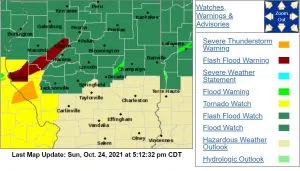
Tornado warnings are posted southeast of St. Louis, Missouri and in southern Illinois. Areas of Peoria, Fulton, and Tazewell Counties have seen severe thunderstorm warnings posted throughout the evening.
There are multiple reports across the region of tree limbs down and other various wind damage, particularly in and around Bloomington-Normal.
Forecasters noted one report of quarter-sized hail in a rural area southeast of Petersburg.
Flash flooding has been the other primary threat throughout the evening hours.
Central Fulton County and eastern Tazewell County have both come under flash flood warnings which have continued well into the nighttime hours.
Earlier Sunday, Illinois Weather issued an advisory on its Facebook page, advising drivers to avoid the roads after dark.
At 9:09, emergency managers received reports of extremely heavy rainfall in an area of Peoria near the Willow Knolls Shopping Center.
Storm watchers in Chillicothe and Lewistown also reported heavy rains of 2 to 5 inches between 7:50 and just after 9 p.m. At 6:30 p.m., waters flooded over Route 100 outside Canton.
———–
UPDATE: 5:03 p.m.
Peoria, Ill — Winds have been howling and heavy rains have been falling in the Peoria area as a storm front hits the area late Sunday afternoon.
Forecasters said they expected to see up to nickel sized hail in some areas this afternoon.
According to the Illinois Weather Facebook page, there is small hail occurring with the strongest storm cells. They’re warning of flash flooding and telling people to stay off the roads after dark if you can.
They say the region has already seen between 1-4″ of rain and is likely to see more behind this line of storms.
National Weather Service forecasters told 1470 & 100.3 WMBD we could expect the threat of severe weather to continue as late as 10 p.m. Sunday.
————
ORIGINAL STORY:
PEORIA, Ill. – Central Illinois should be on the lookout for severe weather through Sunday night.
Rain and thunderstorms will rule the day, but the risk of severe weather will exist after 5 p.m. Sunday.
“The bulk of the severe weather will be south of I-74,” news partner 25 News Chief Meteorologist Chuck Collins said, “but we can’t rule out scattered severe cells around the area.”
“The primary threats are damaging winds, large hail and heavy rain but isolated tornadoes are possible, especially south of I-74.”
Two to four inches of rain is forecast for Central Illinois through Sunday night.
A Flash Flood Watch is in effect until 7 a.m. Monday.

